Question about/plea for help with unincorporated area

Recently I returned to my hometown in Pinellas County, FL for the first time since I started intentionally CityStrides-ing. Or rather, I returned to my home unincorporated area. Growing up I put either of the neighboring cities as my mailing address and as long as the street address and zip were correct, mail made it to my mailbox. As concerns CityStrides, this made me realize that I wouldn’t get credit for all the local named and runnable streets since they don’t exist in CityStrides. I reviewed a relevant post on the topic (My township is not in any city) but didn’t reveal anything actionable for me. Meanwhile, searching the 14,000+ ‘Cities’ in CityStrides for ‘unincorporated’ brings up 5 results: 4 in Australia and 1 in California. Therefore the answer seems to be yes…

I was able to filter and extract the shapefile for unincorporated areas from the county’s GIS database. Now I need to understand how this can be appropriately added to OSM, as there already exist outer boundaries for the municipalities but not for the data I just extracted. I have some aptitude for OSM, but mostly for editing existing features (ie, adding road names) using the online OSM editor, certainly not higher-level manipulations like this.

So before I go deeper down this rabbit hole, I wanted to make explicitly sure - can unincorporated areas be added to CityStrides? And if so, can anyone help me figure out how to do this? :confounded:

My hope is also that maybe we can make a Wiki page for this process for folks to refer to in the future if they have their own boundary data to OSM to get it added to CityStrides.

3 Likes

So is the unincorporated city not apart of another area? Like for where I am the townships can be mixed in within the city but you cant go vote at the same spot. The update in Oct was able to put in admin level 6 so townships could be added. @zbrown4 put in a wiki about the boundary’s Adding Townships to OSM/CityStrides - #6 by zbrown4

1 Like

Hi Missie, thanks for responding. What I’m referring to are definitely just unincorporated areas, which seems to be a pretty common features across the US, but there are quite a lot in Florida - vast urban/suburban sprawl beyond extant municipal boundaries and out into the grassy waste, or just in the space between and never annexed. Based on the link from Zach, it reassures me that these unincorporated areas would be admin level 8 like most others. My problem is the outer boundaries don’t currently exist in OSM and I don’t know how to get them in there, nor do I want to haphazardly try and screw up (I’ve already been chastised for smaller mistakes on OSM in the past!)

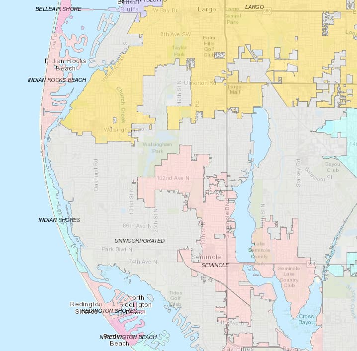
It’s really interesting to me that there is vast amounts of developed land in these unincorporated areas. Dug around about on the county’s GIS portal - I assume you are interested in adding the gray areas in the picture below?

This page is a good resource for understanding how boundaries should be mapped by state. Unfortunately it doesn’t look like there are any clear answers about unincorporated areas. If each area has its own name, then in my opinion it is valid to add them. This is something that is probably worth asking Florida mappers about (there is an OSM Slack, you could ask in #local-florida).

Regardless, here’s some guidance on how to do the actually mapping.

  1. Confirm the data is compatible with the OSM license. I’m not familiar with your local laws, but just because the data is public does not mean it can be added to OSM. This is probably something the local community can help with as well, or if not, you can always contact the county and ask.

  2. Download and get familiar with JOSM if you’re not already. Mapping boundaries and dealing with relations is really difficult with iD (the online editor). Also - this map style is incredible useful when mapping boundaries.

  3. Understanding relations and specifically boundary relations is necessary. It’s a different type of OSM object. You can think of it as a ‘bucket’ that you can put nodes (points) or ways (lines) into to relate them to each other.
    For boundaries, imagine a square boundary like below. You want to map the green boundary. Each side of the square would need to be its own way. The top line would be added to the pink ‘bucket’ and the green ‘bucket’ because it represents both the boundary of the pink area and of the green area. Similarly, the right side of the square would need to be put in the green and purple ‘buckets’ (relations).
    image.

With all that being said, it does not look like existing cities in your area are mapped this way. In your area, the green square has one single line going all the way around and is put only into the green ‘bucket’. The other squares also have a single line going all the way around their own boundary and are again, only put into their own bucket. This is not necessarily wrong, but can be frowned upon because you are duplicating data (each side of the green square is now drawn twice). Hopefully that distinction makes sense. I am going to type out instructions as if you are mapping the first way because I believe that is better practice, but this is something you could ask the local mapping community.

So to start, you can download data for the area you are mapping in JOSM (this should be straightforward once you’re familiar with JOSM).

Then, you can open your shapefile using JOSM, which will show you the data from your file in a new layer. Then you can overlay the shapefile onto the existing data (and imagery if needed). This will help you determine which boundaries currently exist and which need to be drawn.

You will have to create a new relation object for the boundary you are drawing. On this new boundary relation, you add the tags (name=, admin_level=, etc.). Then you can start putting things into this new ‘bucket’ you created.

If the boundary line is not yet drawn, it’s relatively simple. You can trace the boundaries from your shapefile onto the ‘Data Layer’ you downloaded from OSM and add it to the correct buckets.

If some of the boundary line is already drawn (where the city/town/county boundaries already exist), you will want to use those existing lines. These lines should already be in the city/town/county ‘bucket’, you just need to add them to your new ‘bucket’. You will likely have to split the existing line into separate ways to appropriately assign them to their relations. There’s an example of this in the wiki link above.

Once you have added all the lines of the boundary to the bucket, it is drawn and you can upload to OSM. Before uploading, you will want to confirm that the boundary is completely closed (the map style linked above helps with this). I will leave it up to you and the local community to decide whether you should map this way or match the existing method. The existing method is much simpler, but is a similar process, you will just draw the complete boundary as a single line and add the single closed line to the relation.

Here is an example that I drew for reference: Relation: ‪Middleville Township‬ (‪13381376‬) | OpenStreetMap On the left, under members, you will see 6 members. Each of those members is a unique boundary line between two areas.

Hopefully that’s not too confusing despite the wall of text. :slight_smile: It’s really not that complicated once you understand what relations are and how to use JOSM. Best of luck!

6 Likes

This is really extremely thorough, thank you so much for taking the time. I do already have JSON/JOSM but found it cumbersome compared to the online editor for simply updating street names/ adding new roads. But I can see how it’s more valuable when working with a shapefile overlay. I’m not sure when I’ll start to tackle this project but I’ll definitely reach out to the local Florida OSM community before I do. I also hope that if anyone else is thinking of adding data like this they might find your wall of text quite informative. Once again, thank you!

2 Likes

No problem - happy to help! And thanks for the correction there, yes it should be JOSM. Always type JSON by habit…wrong acronym! :slight_smile:

2 Likes

How did I miss this? Great post. Thank you.

I thought I had a new place to look for my shape file, but I was not successful at The Texas General Land Office, George P. Bush, Commissioner

My quest is the shape file for a Census Designated Place in Texas. One would think this would be at https://www.census.gov/ , but I have not been able to crack the code of finding the shape file “Oak Trail Shores”

Even Google knows how to draw the border (link)

But I just can’t seem to find a file.

I’m about to just draw it manually.

Hi Eric,

I was able to get my shapefiles from the GIS web service hosted by my county. I checked your county website and found it there too, but the interface is different and not sure if you can get exactly what you need, but worth playing around with: ArcGIS Web Application Hope this can set you on the right path.

1 Like

Thank you @kevincharlespels, every little bit helps. Will be looking into that shortly.

Cheers, Eric

I made another stab at a shape file search, but so far still no luck.

I have however gotten better at OSM, so I am reasonably certain I will be able to add the border of the “census designated place”, that is my hood.

Several other site do know the shape.

This link shows the area: long URL

As days get colder and shorter, this is how I will keep busy… Adding my hood manually.

1 Like

Also in an unincorporated area of FL, Highlands County, address is Lake Placid (FL). I’d love to hear how your work on this ended up. Seems like so much of FL is done this way, including many communities which seem to really be in the “town,” but are not. Some are even just one street over from the town, so it’s very arbitrary. The next-largest official named area is the county, and although ours is a small county, I think CS for the county would be too big and not really meet the intent. For now, I guess I’ll run in Lake Placid Town proper, while I figure out how to track the streets near my house where I would normally run. It’s kind of ok because there are actually hills (Florida-style) in town!

Sadly I deprioritized it…I was really excited about it while I was on vacation in my hometown (home-unincorporated-area?) in Pinellas County but the shapefiles have been sitting in my downloads folder waiting to be played with…

I hear you. Maybe I can figure something out. For now, I can see it visually on my LifeMap, but if that were enough, I would be satisfied with just knowing what I’ve done from my GPS tracks.
Given how the pavement seems to turn to gravel and then to sand if I go less than a mile down any of these roads, it would also be a benefit to OSM if I were to actually update the information on these ways as well.
One of the issues to rolling-my-own version of the unincorporated area is – what is the actual edge of the part associated with the town. I guess I could go by school districts and/or county voting districts. If you vote in Venus or Sebring, then I guess I can exclude you from Lake Placid…