Yes indeed, those are changed by me, 5 days ago, in an attempt to fix it myself.  But I clearly missed some parts and on this changeset I received a remark about it. ( Changeset: 180717171 | OpenStreetMap )
Ah, right Austria, Belgium, Denmark, France, Hungary, Slovakia, and Switzerland all have that rule where highway=trunk Ways are default to foot=no … the rest of the world have the rule that highway=trunk Ways are default to foot=yes
I haven’t figured out how to address this in my current city sync code.
Sorry to drag this one up again but I’ve been flagged on OSM for setting a road to be foot=no and told to use sidewalk=no instead. Where I’m running in Wychavon there’s a lot of Primary and Secondary roads that are really dangerous to run on (usually 40, 50 and 60mph limits with no pavement, zero verges and blind bends) and lots of quiet, narrow backroads with 60 mph limits that are fine. For the UK, I’m thinking that if a road is marked at Primary or Secondary route and has sidewalk=no tag then we exclude it. Then we can keep in main roads that do have pavements and keep in back lanes that have no pavements and everyone can be happy.
Obviously there aren’t a lot of sidewalk=yes tags on main roads but in my opinion it should be our responsibility as CityStriders to help correct that data and make it better, not make things worse by trying to set foot=no on every main road that comes up, which is what I’ve been trying to do.
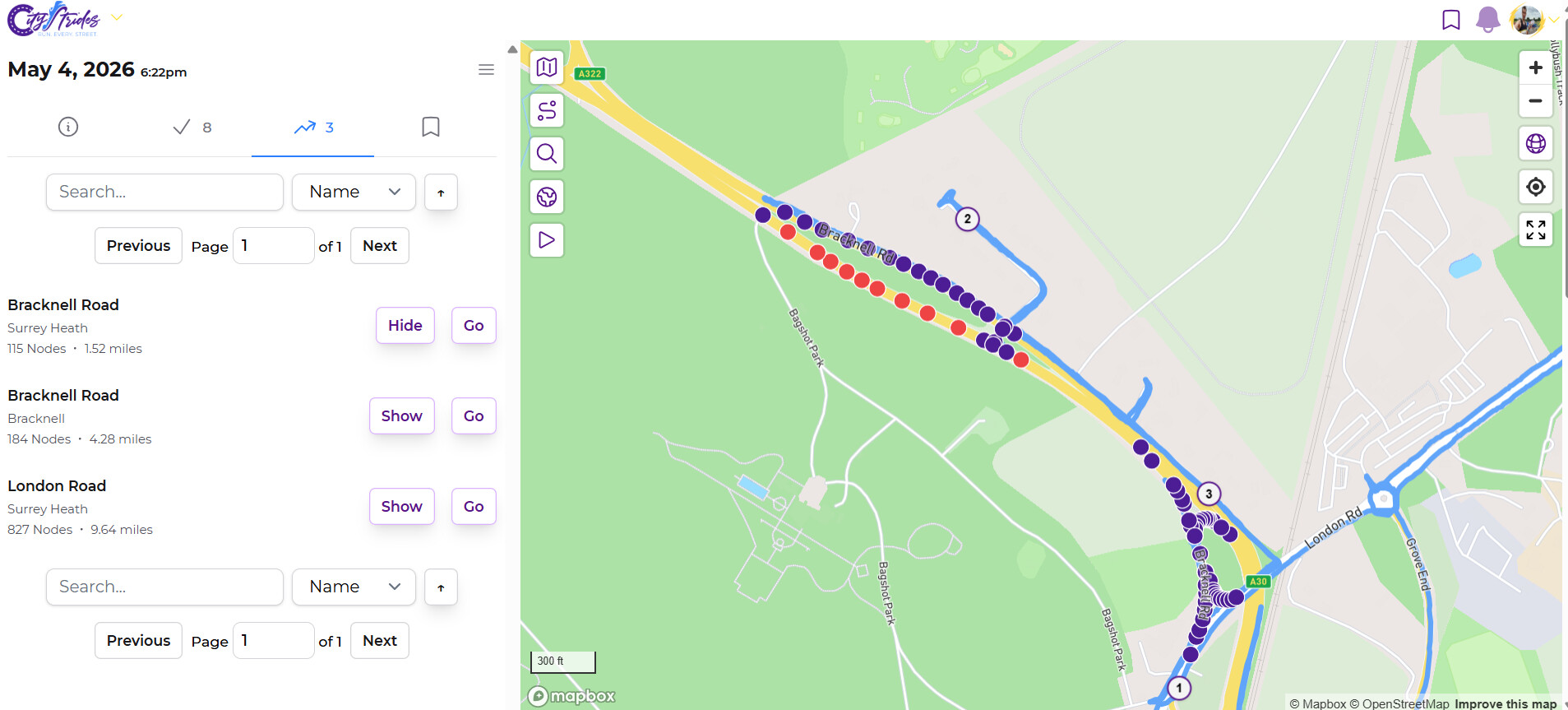
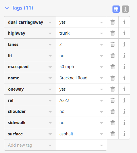
I came across this issue on the segregated A322 dual carriageway near Bagshot. I “got” the nodes on the north side as there is a pavement. I was however more than the 25 metres window to get the other side Bracknell Road - CityStrides The south side is a near motorway and the grass verge currently too overgrown to even attempt to walk/run along. Think might have to resort to Manually marking as done as I feel I have “done” this road albeit one side of it. One part of the bit did not do have these tags and it leads into a section that is actually 70 mph not 50 mph. I just added sidewalk=no here but a trunk road, dual carriageway with no sidewalk is surely that should not be on CS ?
I’ve figured out how to apply the custom rules for Austria, Belgium, Denmark, France, Hungary, Slovakia, and Switzerland (where highway=trunk Ways are default to foot=no). It’s going to take some time to get this in place, though:
- Wait for Boston to finish syncing (hours/days)
- Release the code with the new filter (minutes)
- Rebuild my planet data with the new filter (hours)
- Release the code that uses the new filter data (minutes)
After that’s complete, the following sync for cities in these countries will remove these trunk roads where foot is not set to yes.
There’s some discussion of Primary and Secondary roads which has crept into this thread. That is a completely different topic. This topic is specifically and only about highway=trunk roads.
Further, I’m expecting that diving into highway=primary & highway=secondary is going to uncover a lot of roads to the extent that some other tag situation is going to be required e.g. some combination of maxspeed/foot/sidewalk.
A new post in Support will be the best way to handle that, if anyone wants to carry that along. I’m going to need a lot of research done with lots of example links. It’s way too big of a change to let rip - I’ll get way too many emails 
As somebody striding in Belgium, this is great news, thanks a lot!
Will this fix also apply to roads tagged as highway=trunk_link? I only recently discovered that is a thing, but it seems to be a special case of highway=trunk, rather than highway=primary or secondary.
Here is an example of a highway=trunk_link: Way: Route de Mont Saint-Jean - Steenweg op Sint-Jansberg (39626539) | OpenStreetMap
I don’t have any trunk_link filter in place right now. I do have motorway_link excluded, though. That seems to be close enough to the same thing. Which means it’s probably not.
There’s more detail in the Highway link page, as well. I’m hesitant to add more of the other (primary_link, etc) _link tags to the filter, because there is no primary/secondary/tertiary filtering in place.
There are 41 trunk_link ways in all of Brussels-Capital:
Full list
- Way: Tunnel Stéphanie - Stefaniatunnel (4726718) | OpenStreetMap
- Way: Tunnel Stéphanie - Stefaniatunnel (4730646) | OpenStreetMap
- Way: Avenue Victoria Regina - Victoria Reginalaan (12110878) | OpenStreetMap
- Way: Tunnel Stéphanie - Stefaniatunnel (13548014) | OpenStreetMap
- Way: Tunnel Stéphanie - Stefaniatunnel (13548017) | OpenStreetMap
- Way: Avenue de Cortenbergh - Kortenberglaan (14364220) | OpenStreetMap
- Way: Reyers-Montgomery Tunnel (15380945) | OpenStreetMap
- Way: Reyers-Meiser Tunnel (15380958) | OpenStreetMap
- Way: Reyers-Meiser Tunnel (15416618) | OpenStreetMap
- Way: Reyers-Montgomery Tunnel (15417241) | OpenStreetMap
- Way: Tunnel Joyeuse Entrée - Blijde Inkomsttunnel (22794809) | OpenStreetMap
- Way: Boulevard Auguste Reyers - Auguste Reyerslaan (23165660) | OpenStreetMap
- Way: Avenue de Tervueren - Tervurenlaan (23575842) | OpenStreetMap
- Way: Avenue de Tervueren - Tervurenlaan (23575859) | OpenStreetMap
- Way: Avenue de Roodebeek - Roodebeeklaan (31538312) | OpenStreetMap
- Way: Boulevard de la Woluwe - Woluwedal (34000637) | OpenStreetMap
- Way: Route de Mont Saint-Jean - Steenweg op Sint-Jansberg (39626539) | OpenStreetMap
- Way: Tunnel Louise - Louizatunnel (109398805) | OpenStreetMap
- Way: Tunnel Annie Cordy - Annie Cordytunnel (123372548) | OpenStreetMap
- Way: Tunnel Annie Cordy - Annie Cordytunnel (123372549) | OpenStreetMap
- Way: Tunnel Annie Cordy - Annie Cordytunnel (123372550) | OpenStreetMap
- Way: Tunnel Annie Cordy - Annie Cordytunnel (123372557) | OpenStreetMap
- Way: Tunnel Annie Cordy - Annie Cordytunnel (123372558) | OpenStreetMap
- Way: Tunnel Annie Cordy - Annie Cordytunnel (123372559) | OpenStreetMap
- Way: Tunnel Trône - Troontunnel (124862952) | OpenStreetMap
- Way: Boulevard Auguste Reyers - Auguste Reyerslaan (128637156) | OpenStreetMap
- Way: Avenue de Tervueren - Tervurenlaan (146284126) | OpenStreetMap
- Way: Avenue de Tervueren - Tervurenlaan (146284128) | OpenStreetMap
- Way: Tunnel Stéphanie - Stefaniatunnel (180051973) | OpenStreetMap
- Way: Avenue Émile Bossaert - Émile Bossaertlaan (256655475) | OpenStreetMap
- Way: Avenue de Roodebeek - Roodebeeklaan (265103232) | OpenStreetMap
- Way: Avenue Victoria Regina - Victoria Reginalaan (349372035) | OpenStreetMap
- Way: Avenue Victoria Regina - Victoria Reginalaan (349372036) | OpenStreetMap
- Way: Boulevard Auguste Reyers - Auguste Reyerslaan (365912125) | OpenStreetMap
- Way: Boulevard Auguste Reyers - Auguste Reyerslaan (365912390) | OpenStreetMap
- Way: Tunnel Stéphanie - Stefaniatunnel (393494867) | OpenStreetMap
- Way: Boulevard de la Woluwe - Woluwedal (628312610) | OpenStreetMap
- Way: Boulevard de la Woluwe - Woluwedal (628312611) | OpenStreetMap
- Way: Avenue de Tervueren - Tervurenlaan (636940959) | OpenStreetMap
- Way: Boulevard Auguste Reyers - Auguste Reyerslaan (818067740) | OpenStreetMap
- Way: Boulevard Auguste Reyers - Auguste Reyerslaan (1301073240) | OpenStreetMap
I’m inclined to add the filter, but  it’s probably best to have a number of us spot-check some links in there to see what things look like…
Going through the list, none of them seem unreasonable to exclude for me (though I guess that does not come as a surprise  ).
).
Many are part of a tunnel, which means they are not picked up by citystrides anyway. Example:
A lot of the others are an entry to / exit from a tunnel, which you’re not allowed to access as a pedestrian:
- Way: Avenue de Cortenbergh - Kortenberglaan (14364220) | OpenStreetMap (entrance to a highway tunnel)
- Way: Reyers-Meiser Tunnel (15416618) | OpenStreetMap (another entrance to another highway tunnel)
Most of the remaining ones link a major arterial node (that you’re not allowed to walk on) to the regular road network:
- Way: Avenue de Tervueren - Tervurenlaan (636940959) | OpenStreetMap
- Way: Boulevard de la Woluwe - Woluwedal (34000637) | OpenStreetMap
I have completed these, but that’s mainly by passing by close enough on the normal roads that run parallel to these roads.
Then there is this one, which is just an on ramp to a highway (which is classified as a trunk road, since it is not a highway legally)
TL;DR: they all link trunk roads to “normal” roads.
In my experience, the _link postfix exists for all ramps etc on/off the highway that it is getting postfixed to. If you filter out trunk in a certain country, then it definitely makes sense to me to also filter out trunk_link. It’s a ramp, the police is going to pull you over if you’re not supposed to be on the main thing it connects you to.
Brussels-capital region just got updated and it seems that the trunk roads are still there. Is it possible that there is an issue with the custom rules? Or did you simply not have time to get everything in place yet?
I have the code changes that should do this, but I haven’t released them. I want to double/triple check before changing eligible streets like this because people get upset when things change, and upset people send emails. To me.
Sorry for bumping this thread (again). However, the latest sync of Brussels capital region has introduced some strangeness with the existing trunk roads:
- This road is tagged as
highway:trunkand still required: Boulevard Henri Simonet - Henri Simonetlaan - CityStrides (osm) - This road is tagged as
highway:trunk_linkand no longer required after the sync: Route de Mont Saint-Jean - Steenweg op Sint-Jansberg - CityStrides (osm)
Both roads have not been modified on OSM since the previous sync.
Is this related to the changes discussed in this thread? Or is this just a coincidence?
I have updated the sync code between the two times this city last synced…
I fully exclude trunk_link from CityStrides entirely. There might be some cases where Ways tagged with that should be in CityStrides, but I haven’t heard anyone complain yet.
The Way records in Austria, Belgium, Denmark, France, Hungary, Slovakia, and Switzerland that are tagged as trunk will (erm, “should” as we’re finding here) only arrive in CityStrides if they are also tagged as foot=yes
I’ll need to look into why that foot=yes requirement isn’t kicking in…
Update: I can’t get the code to return this Way (well, it does include this cross street of the same name). This is going to require more research. 