On a related note. I was on the English-Welsh border on a single carriageway A road near Wrexham and there were a load of no pedestrian red circular signs. Can only assume this is because the road forms a long bridge high over the ground below and wonder if has seen some falling off as it were. As roads go I have seen far more dangerous ones to walk along which are technically legal for pedestrians
I ended up running St Peter's Way - CityStrides the other day. Somebody said on my Strava that was surprised I get did not arrested for running on a dual carriageway. Well I did not actually run “in” the dual carriageway. Half of the first section was behind bollards due to roadworks and the other had a small “hard shoulder”. I feel I should not be running on this but if the rules here “encourage” me to do so I kind of feel I “have to”.
In another city (Mole Valley) I now have some more “major roads” to complete. Bit of a giveaway that “Bypass” and/or the length of them means more designed for high speed cars than runners. That said looks like I have already done “most of them” as of course some parts have sidewalks and/or are generally “OK”…
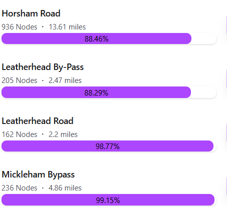
Did something in the OSM query change? I also have several cities that are no longer 100% and are due to red nodes on on rather busy roads they were previously void of red red nodes.
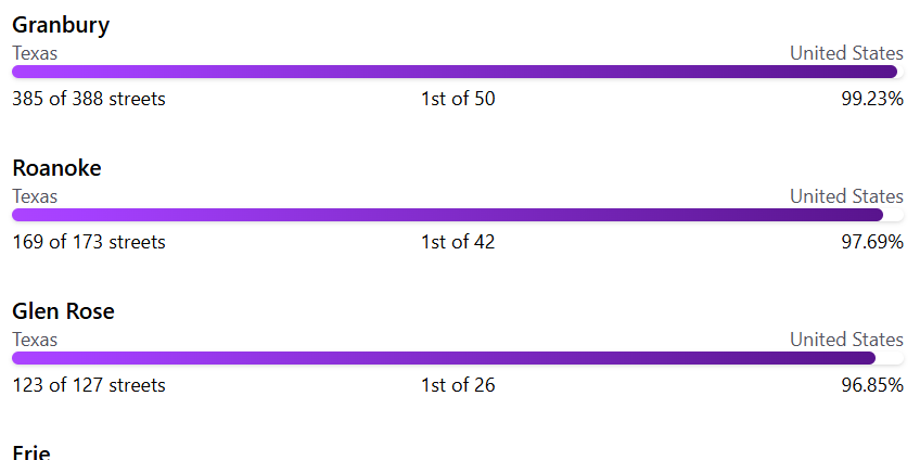
At first I thought it was just Granbury, but it seems rather wide spread. Some of the new red nodes are reasonably safe to run, but others are not. It just seems odd that there are all the “new” red nodes.
Probably this from July 25: The Trouble with Trunk Roads - #22 by JamesChevalier
Thank you Hans! Looks like I have some tag editing to do.
The data source is a publicly editable dataset which can be inaccurate either due to mistakes or vandalism. That data changes a lot at a rapid pace, and I have code that keeps things as up to date as possible. The streets listed in CityStrides are a best effort display of streets in your cities. There are many streets that are incorrectly included in these lists because the data source is incorrect. We handle that by correcting the data source (or adjusting the parameters of what should be included, where possible/relevant) and/or marking the street as manually completed in CityStrides.
This is your complete thought which has come to the correct conclusion.
So is the basic conclusion with these “dangerous” roads that we should mark them as foot=no on the belief that we should not be on them but risk the wrath of OSM community over legal definitions or accept we cannot ever finish the respective city - well in Hard Mode? As such whether it is marked as having a sidewalk or not is not considered ?
That said I did mark foot=no the revised and enlarged roundabout with our notorious M25 London orbital motorway and the A3 trunk Road as the sidewalk that used to be there has basically gone while they widen the whole area. For pedestrians they have provided not yet open footbridges basically at the 4 points of the roundabout but somewhat set back so you could not pick up the ground level nodes from on high as it were.
No, I don’t think there’s any conclusion with this yet. Pretty much everything about CityStrides is still a work in progress, and there just happens to be a lot more publicly visible work that’s required right now.
We’re all in agreement that these roads are unfit for pedestrians and I want to figure out a way to exclude them in CityStrides while playing nice within the OSM community. Maybe there’s some tagging that accomplishes this, maybe the query needs to be changed, maybe trunk roads in the UK should be excluded. We’re all here trying to figure it out.
In the meantime, we each need to remember that we’re individually responsible for our own health and safety. That responsibility comes first, and all the fun things we can do follow after.
It seems they are dangerous for 2 reasons: 1) There is no sidewalk and 2) they are high-speed roads (non residential). Marking them as foot=no is clearly against OSM rules, but this could be a query based on speed limit (>50 km/hr / 30 mph) combined with “sidewalk=no” could likely capture this. There are a few other options in Key:sidewalk - OpenStreetMap Wiki that could be valid as well. This does not cover the case of divided highways with one-sided sidewalks if the GPS track doesn’t get within x of the nodes, but this would likely filter out all undesirable places to run.
There is always the risk to remove streets that should not be removed, but that would mostly be rural roads where running would only be reasonable due to low traffic volume, while road design as a whole would make running unsafe on a road like that if it had consistent traffic.
One solution is to reverse the decision to include trunk roads. I know some people were annoyed that there were walkable roads that weren’t included in CS. But for me there are two methods of tracking progress - the stats that CS provides about the number of streets completed and the visual filling in of the Life Map with purple lines. The latter already comes into play a lot for me because I try to complete all streets, rather than collect nodes. So I will (almost always) make sure I’ve walked parts of streets even after CS tells me I’ve completed it.
Apart from the problem of walkability of some trunk roads being questionable (something that varies from country to country, and varies between different trunk roads even in the same city), this change means that lots of us are going to gradually see cities we thought we’d completed suddenly showing as incomplete. There are main roads through some suburbs in Sydney (counted as cities) that are safe and legal to walk but are horrible to walk because they’re noisy traffic funnels with wastelands of used car dealerships and fast food joints. While I’ve personally made the decision to fill every “white road” with purple, I decided I was quite happy to leave the yellow roads still yellow. Had trunk roads been included when I first started Citystriding, I would probably have completed the yellow streets too, but I’m not enthused about going back to complete them once the relevant cities next update and they revert to incomplete status, especially as some are safe and legal but some sections aren’t and I can’t always tell where their status / characteristics change without travelling there.
I know there’s the age old problem of not being able to keep everyone happy. I don’t want to minimise / downplay the challenge of that. But if yellow roads weren’t included, those who want to walk them can still fill them in on their own LifeMaps in purple.
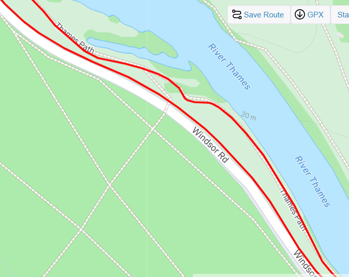
It’s a tricky one for sure. I am almost done with “Runnymede” in Surrey in the UK. Yesterday on the last few to do was a single dual carriageway 40 mph road Windsor Road - CityStrides with no sidewalk immediately adjacent to the road but as it goes through an area very popular for walkers (where the Magna Carta was signed) there are lots of paths set back a bit from the road and one which is at least sort of “parallel”. I did however think, especially in Hard Mode that I use, that it may well leave me with isolated nodes to complete when say the path is further set back. In the attached Strava screenshot I did the “road” on way out and kept to the path on way. Clearly the path was more pleasant and actually I got shouted twice that I should be on the path - once by a cyclist ironically on the road going the other way and once by a passing motorist who think was annoyed that my presence meant had to slow down momentarily even though only 40 mph anyway.
Here is StreetView at a point I would say that the path is possibly too far setup back to “count” Google Maps
Ironically I can see a cyclist in the image so it is “OK” for them and yet this runner (even in a bright pink top) was not at all “welcome” - partly for my perceived “safety” but really I think a not untypical irate motorist losing a few seconds that am sure they soon caught up by the next traffic lights further up.
Now this is neither a “trunk” road, nor a dual carriageway nor has an overly high max speed and yet it “probably” should not be one we should be doing. Conversely I have run on single carriageway supposedly 60 mph rural A “primary” roads with no sidewalks but have felt perfectly safe - largely as clear of trees, bends and a fairly wide road.
So my main point is that unless you really “know” a road, it can be hard to be sure if it is one you feel OK to run/walk down.
I feel that a “good” solution could be the foot=discouraged setting. The big problem with that is that the notes on OSM say it is itself discouraged - think largely as the real world examples of such a sign “on the ground” are minimal and then, I suppose, it becomes a subjective setting.
Another thought is like a segment on Strava that you can suggest is unsafe/unsuitable and it gets downgraded accordingly. So maybe that is another possible suggestion albeit then needing some extra data layer over OSM and again subjective to opinion. I guess like the Sydney example running past/through “wastelands” may not be pleasant but if you are Strider you basically have to accept that no every run would be one you would choose to do for its nice surroundings…