I just had one “dead-end” road to complete in my village which seems forever behind a locked gate although Google Street View does show it open in 2 views about 10 years ago! I had hoped to “nip in” but then thought, even if I nip behind a car coming out, what if I can’t get back out again so have just done my first edit in OSM and have hopefully marked it as a private road. Assuming this works there are few other similar ones I think I will need to also mark.
More tricky however is that the A3 3 lane trunk road passes quite close to me. It is not a motorway per se but essentially it is as it has a hard shoulder alongside 70 mph traffic but, in a lot of places, there is no pavement/sidewalk/cycle path. In other words you would be risking life and limb to tick off those nodes. I am not sure however what the general policy is with such roads in excluding them? Don’t really want to exclude the whole road from Surrey to the south coast as many parts have safely runable bits to the side as mentioned.
Luckily, the general approach within the OpenStreetMap editing community falls inline with how we use streets in CityStrides. There are some tags that can be applied to streets to mark them as unsafe for pedestrians.
There are a few options, and the OSM is particular - so I don’t know exactly which tag is the ‘correct’ tag in your case. It might be one of these, or it might be something else:
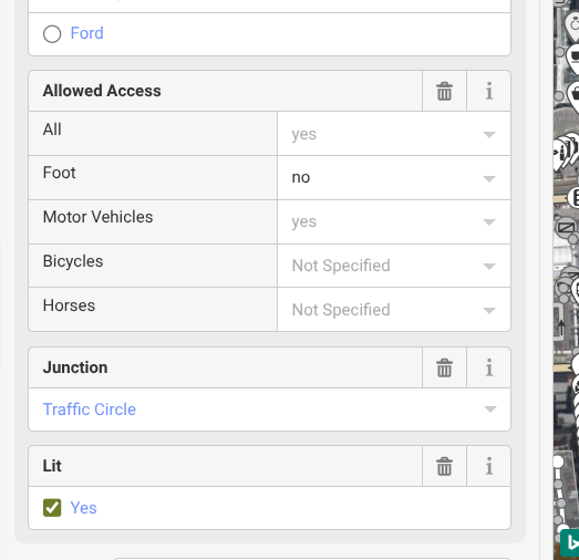
In this instance, access “all” itself should remain yes, and foot should be “no”. Do not do this for the full road, but rather split the way into the portions that don’t allow for foot traffic.
Thanks. Will have a go with Foot=No later.
As an aside how long does it typically take for OSM updates to make it here? I noticed 1 road with a node I need was already marked private but is also behind a locked “keycode” gate as mentioned.
There is currently no update feature for OSM>CS, but it is in the works. Your updates won’t be in vain, but it may take a while for them to make it up here. In the meantime, when I make updates such as marking something private, I just mark it manually complete in CS so the nodes don’t keep showing up on my lifemap.
I think the current query explicitly excludes trunk roads. This part wasn’t in the initial query, so if @tim1’s city was one of the early imports it’s possible that that road will disappear once the map data is updated in CS, hard to tell without knowing the city.
I’ve run a few sections like that (70km/h, no shoulder), definitely not fun, can’t recommend.
Edit: it looks like the A3 is tagged highway = trunk, so it will be gone as a runnable street in CS with the map update, no editing in OSM required.
Noticed another issue here. In an OSM am looking at some of these gated dead-ends with nodes at the end can’t get to. Some have a gate symbol with “private” access and yet the road the gate sits on is marked as normal all access. Surely both should be private and is the fact that CityStrides is showing nodes “behind the gate” due to looking at the road status and ignoring the gate?
My guess is that when the streets were imported status of those streets was not set to private. After the import someone has changed it to real life situation
Just wondering if I should make those dead-end roads “private” as well as the gate which seems you can set access on as well. Clearly makes no sense to have a private gate guarding a public dead-end road!
Yes, mark the road as private as well. CS only imports OSM ways, so nodes (like gates) don’t get imported and there’s no way to know a road beyond a gate would be private unless the road is marked as private!
Just in case this clarification is helpful:
The code collects all of the ways and their nodes for any way within a city border.
You’re correct that the code does not directly query for nodes, on their own.
Also related: New city imports do not include nodes outside of city borders, but older city imports did. I haven’t cleaned that data yet.
Hi, trunk roads have now been included in node generation but as per the original post, in the UK the legal status of all roads except motorways is that pedestrians are allowed. Even 70 mph dual carriageways with no pavement. Having had a quick look on the OSMwiki page, the access for pedestrians should therefore be set as yes. This should reflect the legal status rather than practical status. This seems to go against your advice, so as a very inexperienced OSM user I am very confused. Any help uou could give would be grately appreciated.
I am editing OSM trunks roads in my UK city as I find a issue after I have walked it. If it is impossible to collect the node I edit OSM so it is Foot NO simply becuase there is no footpath
Reading the wiki pages for OSM I don’t think this is correct. They say allowed access is the legal access not the practical access. However, I am not experienced with this aspect and am trying to get advice from those that know more. Tags seem to be a less intrinsic change to a road status but still achieve the same outcome for city strides purposes (I hope, as currently untested)
I think this situation might a good reason to use foot=discouraged but ironically Key:access - OpenStreetMap Wiki says the use of this tag is discouraged.
In the UK I can think of places like the Hindhead Tunnel (on the A3 in fact) where there are signs prohibiting use by pedestrians or indeed cyclists. Generally though even on the 3 lane 70 mph sections with no “sidewalk” there are such signs but I kind of feel if the police saw somebody walking along such a road they may well stop and ask what they are up to - more for their own safety.
So yeah access=no is probably “strictly” incorrect in the main but there does not seem to be a satisfactory alternative.
A “worst” section is St Peter’s Way in Addlestone in the UK as this is dual carriageway connection road from both sides to the M25 motorway. As it is “only” a primary road, it appears on City Strides as one to run including the roundabout with high speed filters on and off the motorway. I do note in the highway code, it says pedestrians are banned from motorway slip roads which sort of implies that pedestrians are implicity disallowed from the roundabout if not the dual carriageways to the roundabout. It is currently being upgraded to be a 3 lane carriageway so if I tried to run it now, I might also be in trouble for accessing a building site!
It may not be within the OSM rules but I have just marked a couple of sections of Tippet’s Corner in Putney as Foot No as these are an elevated sections with barriers both sides of the road, i.e. you would have to walk in the road rather than next to it and I am not going to do that on a busy dual carriageway.
TBH I do not see how walking there could be legal as to do so would cause chaos there and on surrounding roads; I’d expect to be hauled away by the Police and sternly told not to do that again.