And when I compare to StreetFerret, six of them look OK, and only three are shown as not completed

1 Like
Yeah I see some weird things. It doesnt like boarders and several roads are not there. But that helped me find a few roads I ran but didnt realize have names. So I got to do several updates. Its very easy to spot roads that need to be ran.
1 Like
A post was split to a new topic: Streets not marked as complete
I just had a thought on this subject.
Now that the total distance for each city is part of the city entry, might there be some “completion metric” that compares “stride miles” to “city miles”? In @8f7162110d9eeaf907ab’s example (link), I suspect the Stride miles is going to be (much) less than actual city miles.
Perhaps in this case, a  could appear next to the person, indicating something is fishy.
In most cases, if not all, Stride miles should always be more than city miles. In fact, I think at one time I posed (or maybe just thought) there should be a “city efficiency” metric. A number less than 1 would be the “something is y” metric, and the person with the smallest number greater one… Well you probably get the idea, but also will figure out this idea is not necessarily going to be accurate, as extra legitimate miles, can mask y miles. Note: a metric > 1, but very close to one, seems very unlikely.
I (kinda) say this in jest, because, while I really enjoy being the first person to complete several (admittedly smaller) cities in my area, my real satisfaction comes from knowing I got  % in a city… In fact, I typically go back to 100% cities when/if I see (from my Lifemap) that I “missed” 100% of a street.
Update: Look what I found: Efficiency Score based on miles in a city & miles run
3 Likes
This is a little off topic, but I have been trying find, for the past 60 minutes, a post I came across (after posting the above) about a ride activity getting changed to a run activity so it would sync with CS. But now, for the life of me, I can’t find it…
But it made me think about avg. speed on activities, and running vs. riding activities, and the subject of y data.
Personally, I don’t think there should be any policing/labeling/“shaming”, etc, based on stats, trying to nudge some users’ behaviors to be closer to others’ view of the ideal. That just tends to split us as a community, in my opinion.
I would much rather that there be more users (and therefore potentially more supporters), using the site in a way that brings them the most enjoyment. Maybe I’m biased because I started out as a “node hunter” before I became a “street hunter”, and actually found extra pleasure in realizing that even after I hit 100% of nodes, I had actually only run about 85% of the streets.
7 Likes
After I finished my home town to 100% a year ago, I wanted my Lifemap to look more complete, so I ran a lot of footways and paths where there were ”too much” gaps. I have since done two more neighbours to 100%, and now working on Stockholm, just reached 25% (out of 4200 streets). And I’ve always followed the All streets model
But recently I also discovered Wandrer which also includes all footways, paths and cycleways, and found that I was only at 85% completion of my home town. So the last month I’ve been back here working my way up, now at 95%. It will be really difficult, or maybe even impossible to reach 100%, due to the way Wandrer is organized, but I’ll get very close at least, in a few weeks! But it’s so hard that I won’t try it in any other city😅
2 Likes
I think this is a perfect example of how striders can use CS to creating motivating, challenging, and rewarding objectives in their training. It creates a pretty amazing LifeMap also. 
2 Likes
I think this behavior stems from having a leaderboard. There are so many different ways we can use CS to motivate ourselves and it’s hard to bundle everyone under a single category. Some may have the most nodes, the most streets, the most parks, the most trails, or even the most mileage in each category. Ultimately, all that matters is we are all being motivated by this great tool, created by James, to complete whatever goals we can come up with and feel a sense of pride and accomplishment in doing so.
7 Likes
Very sensible take. At the end of the day, I’m the only one who cares about my CS goals and about the rules I set myself to get there, same as everyone else who uses the site.
2 Likes
Very good point. I like knowing I was the “first” in some cities, but, and I think I’ve said this before, I’m doing this (CS) for me and my own personal satisfaction.
That being said, I can’t say that it would not bother me at (it would, just a little), if someone else was “first” @ 100% with less than 100% of actual miles (now that CS has that too).
But, and this is what I said before, maybe even way up there ^^^, to get 100%, you do have run on every street, just maybe not on all of every street… Assuming no manual completions.
I’m enjoying the heck out of CS, even not knowing who is nipping at my heels in Keller.
Keep up the great work James!
@ericjrw
I understand the range of emotions that you feel. Having a leaderboard makes it easy to find striders who are doing some amazing things with their LifeMaps, but not so great when you see groups of striders with different objectives together on a single leaderboard. Running for nodes, running streets, running trails, or even running for total mileage are much different from each other and should be grouped accordingly. Hopefully, some day, the leaderboard will have categories with clear cut rules.
1 Like
Excellent points @edsheldon. I hope I did not come across as against a leaderboard, was merely stating an opinion (and observation). I’ve been on enough websites, that collect data, to realize there are always going to be people that want to “game the system” and be at the top. It is a fact of our digital life.
I have the upmost respect for CS and James. I am amazed at what he has done, and appreciate the fact that I stumbled across it (pre-pandemic even).
Sincerely, Eric
1 Like
My wife was looking over my shoulder as I was reading this thread, and made the comment that the “node gatherers” should be applauded for their planning efforts. Made me think, maybe there needs to be a badge for that. ![]()
3 Likes
Good Suggestion! I like a random badge ![]()
1 Like
I was surprised to see this great thread end on the topic of badges. As I was re-reading the posts, it made me think there should be a badge, and/or leaderboard, for the strider who has the most miles logged in a city.
Would give the idea of re-running a city all new meaning!
Was just looking to see if there was an existing thread on this topic. I have noted that in certain parts of the world grid layouts are much more common than they are in the UK.
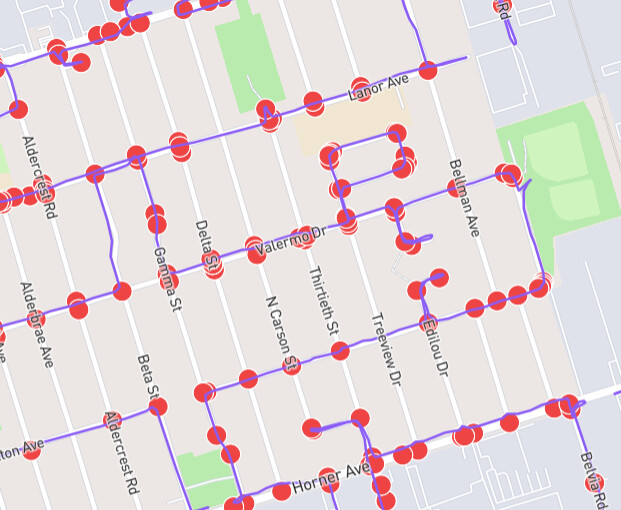
I see in this “random” example somebody has completed all the nodes but seemingly just by running less than half of the actual roads. Mostly where I run this sort of layout is rarely seen.
So is City Strides really designed to encourage us run “every street” or “every intersection” ?
Personally I just don’t like to see any whitespace on my life map and why I turned on Hard Mode although that would have no real effect in small grid layouts. I often even run unnamed service roads.
Be good if there was a way to tweak the algorithm to only credit being given a street if you actually ran it. I understand a “rival” site does this already somehow.
It would “bug” me to earn streets this way. Sometimes I might get “given” one if it is a short one very close to another street. I try and make a point of actually going up it next time.
For what it is worth, @JamesChevalier , in my local setup I postprocess ways with ST_Segmentize to ensure there are extra nodes added in-between.
I’ll have to look into that, because the closest I’ve come is using ST_Snap with the original linestring and the data from ST_LineInterpolatePoints … and that’s excessive because it adds nodes every e.g. 10% regardless of whether it’s needed.
Edit: I suppose it’s not that different - ST_Segmentize uses an exact meters distance between each coordinate, whereas ST_LineInterpolatePoints uses a percentage amount of the length of the way. It probably makes more sense to use ST_Segmentize, so that it’s a known quantity.
I don’t know how I didn’t find this thread before ![]() Anyhow, I’ll probably be in a minority, but:
Anyhow, I’ll probably be in a minority, but:
CS for me is FUN. Nothing serious, so I wouldn’t even “debate”, “argue” or something about the “right way”. And I am not ashamed of doing node-hunting at all. But let me elaborate a bit.
I have had this debate with myself long ago, and my conclusion was, that I… don’t want to have an opinion on this. This is in the fun part of my life, I don’t want to think about how this could be better, or more truthful, etc. I do that plenty in my job. I accept the site logic as it is, and play by the rules. Simple as that. If the rules change, I may or may not be happy, but I accept that too. (Of course, if they change a lot, that is not ideal.)
So yes, I hunt nodes, especially on places where I know I have limited opportunity, or the neighborhood is not really worth visiting several times (industrial areas, etc.). Last weekend I visited Palermo in Italy. I’ll probably never go back there, so me and my friend were hunting streets as crazy. But it was a balance of going somewhere picturesque, and getting as many streets as possible while staying in our distance limit.
Another situation, that happened plenty of times in the summer: I change trains in a small town. I have 25 minutes. It is absolutely fun to go out and collect as many streets/nodes as I can. Without CS I’d just sit on a banch.
Note, that I poisoned quite a few of my friends with this hobby, and with some of them we actively track how we stand, day by day. So, I often just go for the nodes, and increase my “official counter”, and I do all the tricky tactics. But even if I’m ahead of someone in the ranking of a city, I’d not state that I ran the city better or anything. I’m simply ahead of that runner according to the rules of CS. And at the end of the day, that thing only matters until it is fun.
I accept all the quirks and “failures” the algorithm has. There is the issue of nested cities as well. (I know some or maybe all of that is fixed now) But I have actually found fun in that: Several (a lot) of cities in my country are also under an umbrella “city” (technically a religious county). So when I ran Strawberry street in one of them, I got 2 streets, because none of the other cities had that. But 5 cities had “Foobar street”, and in the “umbrella city” the nodes of all of them belonged to this. So if I do all 5, I get not 5 but 6 streets officially. Which I actually liked a lot. It was kind of finding a set combo.
On the other hand: In my own cities - as many people said before me - I really try to run/walk everything. Like others, it annoys me if not. Even streets that are not marked. Trails, small stairways, everything that I find. I often use CS to plan my route on a trail, to discover new paths I’ve never taken. I want to make my purple spiderweb as dense as possible. (I also want them connected, that is another fun thing to do with CS)
Now, should the site add more middle nodes? Tbh, I don’t think so. I’d even argue, that less would be enough (at curves, there could be an algorithm to drop nodes if they are pretty close by). Each additional node probably means additional storage, computation, and hence cost and CO2 footprint. I don’t think that is really needed. If someone really wants to cheat, they can bike, or edit a fake GPX track, etc. I try not to get too serious about these leaderboards. (Strava segments, is that you?!) CS is not an official athletic organization with judges and everything. It is a website to have fun, and I don’t think it is a good idea to move into that direction. But that is only my (probably minority) opinion.
The bottom line: I’m thankful that the website exists, and for all the fun we have with it. If someone else has fun with it in a different way, good for them too ![]() Sorry for the long post.
Sorry for the long post.
5 Likes