Hi. My town has a few roads that only have a sidewalk on one side, and they are so wide that running on the sidewalk doesn’t reach the nodes on the other side. How does everyone handle such roads?
I ran a few of them early in the morning before traffic picked up, and just ran in the ditch. But looking at some that doesn’t seem to be an option (too much traffic, or the ditch is someone’s backyard,…).
Craziest example: Traffic on this road goes north-south on a bridge over an interstate. Traffic from south crosses to the left of the road at the first lights/intersection, and goes back to the right on the other side of the interstate. Traffic from north does the same. There is a bike path that goes close on top of the bridge, but farther away at the intersections. (I ran the path to see if it was close enough, and even though the GPS glitched towards west, it didn’t glitch enough, lol.)
For that wild example (unrelated, but WHY do those streets swap sides like that?!) is there a sidewalk on either of the north/south streets? Can you share links to those streets in CityStrides? (find the street in the city list and click the “Go” button and copy its URL)
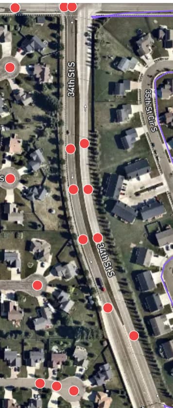
For the 34th St S example, this looks quite pedestrian unfriendly. Perhaps the street with the sidewalk (west side) should exist in CityStrides and the other side (eastern lane) should be tagged in OSM as foot = no or some other tagging that represents “people on foot are not safe here”
I’m wondering if, overall, the issue isn’t how you - as a person walking/running - can complete these nodes … but rather how we - as people with editing capability in OpenStreetMap - can adjust the tagging of the streets to properly represent them as unsafe for pedestrians.
Thanks for the feedback! I have looked into the OSM once and even tagged something as no foot (2 nodes on a weigh station on an interstate with no secondary access), but didn’t know if this was an option here.
Here is the URL for 8th Street South. Locally dubbed “the supercollider”, even though there are a lot less accidents than you’d think. Traffic flow is pretty good if you need to go on the interstate in either direction, so people just got used to it. The traffic lights look funny too, I’ll try to get a picture.
But no, there are no sidewalks, only shoulders and grass. (The map shows it while it was constructed. Google Maps Link)
Here’s 34th Street South, which has a few problematic nodes. For example the intersection where it connects to the interstate, the ramp nodes are literally next to a “no pedestrian” sign For some reason, the south nodes were completed by running on the western sidewalk, but the northern ones didn’t.
Another thing to note is that you only need to hit 90% of nodes to complete a street, so it may still be possible to complete these streets while skipping problematic nodes. If that’s not possible and you don’t want to edit OSM, you could always mark it manually complete.
One could run enough nodes to have that street as completed in CS, but then your lifemap is not covering the complete street. For me that would be a no go.
But tagging roads that are dangerous on foot with foot =no would reflect real life situation in those streets more accurate, so that would be the way to go. imho
I agree, the red nodes just stick out.
I think the solution I’m most comfortable with is to run the streets on the safe sidewalk, and then get more confident editing the OSM for the nodes that weren’t reached from the sidewalk.