I have noticed sometimes that when I complete a street it comes up progressed, when I “check it out” the street that I’ve ran I have all green nodes but at the other side of my city it shows me there is a street with the same name with all red nodes because I haven’t ran that part of my city yet.
I have manually completed the one I progressed(completed) but does that mean I have manually completed the one I haven’t. I’m a bit confused how to get round this.
But that is easy! run the street on the other side of the city! it’s a street, so run it.
But does it count as one street or 2 ? That’s my point
As far as i know, it’s one street. It would not be possible to know programming wise for James that it’s 2 streets, or one street with lot’s of space between the nodes. A software way could be to determine street uniqueness by incorporating the village/dirstrict/town/city/whatever by splitting identically named streets into 2 streets.
But i guess, it’s not THAT important, for me the main goal is the lifemap, and painting all the streets with my gps runs. When all strets are covered, that’s 100%. Done
Yeah petje it really is not that important, I agree with your last paragraph also, the proof will be in the picture.
There is a problem in Greece (and I assume in other countries too) when the governement decided to megre 2,3 or more towns/cities together as a new city. Obviously this has caused a large amount of streets with the same name in the same municipality However, this might not be a problem in real life, for in various map apps you just type the neighborhood.
Now I have completed some streets and they dont appear as completed.
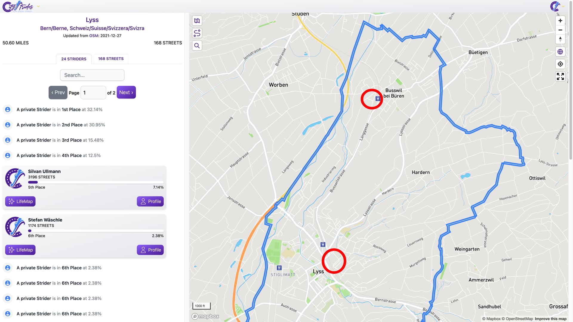
Today I ran in Lyss BE, Switzerland and thought I completed some streets. After I saw, that some of them weren’t marked as done. After clicking “Go” I saw, that the village nearby has a street with the same name which I didn’t run though. This is an error I think.
Example: Bahnweg - CityStrides
I’m not familiar with your area but according to the data pulled in from OSM, both sections of Bahnweg fall within the borders of Lyss, Bern/Berne - CityStrides. Below is roughly marking where the split sections of the street are.
Thanks for your answer, I suspected something similar.
Your statement is correct as Busswil has joined Lyss a few years ago. But it is still named ‘Busswil’ though it belongs to Lyss. Another question is: How reasonable is it to treat streeets as one that are kilometers away from the other?
I think it’s pretty reasonable for the purposes of CityStrides & ease of storing in a database. Even if they were treated as separate streets, you’d still need to run both in order to complete a city.
Historically the separate sections could have been a part of one long street long ago. Over decades the city may have grown and developments split the sections but they kept their original name. In that sense I think it makes sense to treat them as a single, split street.
The underlying issue is that OpenStreetMap (my data source) has no concept of “streets”. It only understands “way” records. I create the concept of streets in CityStrides by joining up everything with the same name within a city.
Sometimes that’s wrong, but it was the best I had (while also considering maintenance & actually releasing code).
Another approach, if I suddenly find myself with lots of free time (Narrator’s voice: hah), might be to store the way records in my database & create relations between those that form a full street (maybe even initially creating this relation via duplicate name) … then put into place some process that would allow ‘breaking’ that relation (and have this ‘break’ persist across updates from OSM). So in your example, I’d be able to view the different way records that comprise Bahnweg & mark them as not a single street.
This is all very much in the “good enough” space, though. It’s a little irritating in places, but overall it “works” enough that I feel it’s better to put my time & effort into other things like making the Challenges actually nice to use. ![]()
I think that might create more problems. For example, the street I live in crosses another street and continues on the other side, but it is not exactly lined up. So the 2 ways don’t share any nodes. This is actually a very common scenario because the section in between might not be imported into CS with the same name, or not at all.
Hello Team,
I found out in my last 2 runs that there are some streets I fully ran that were not accounted.
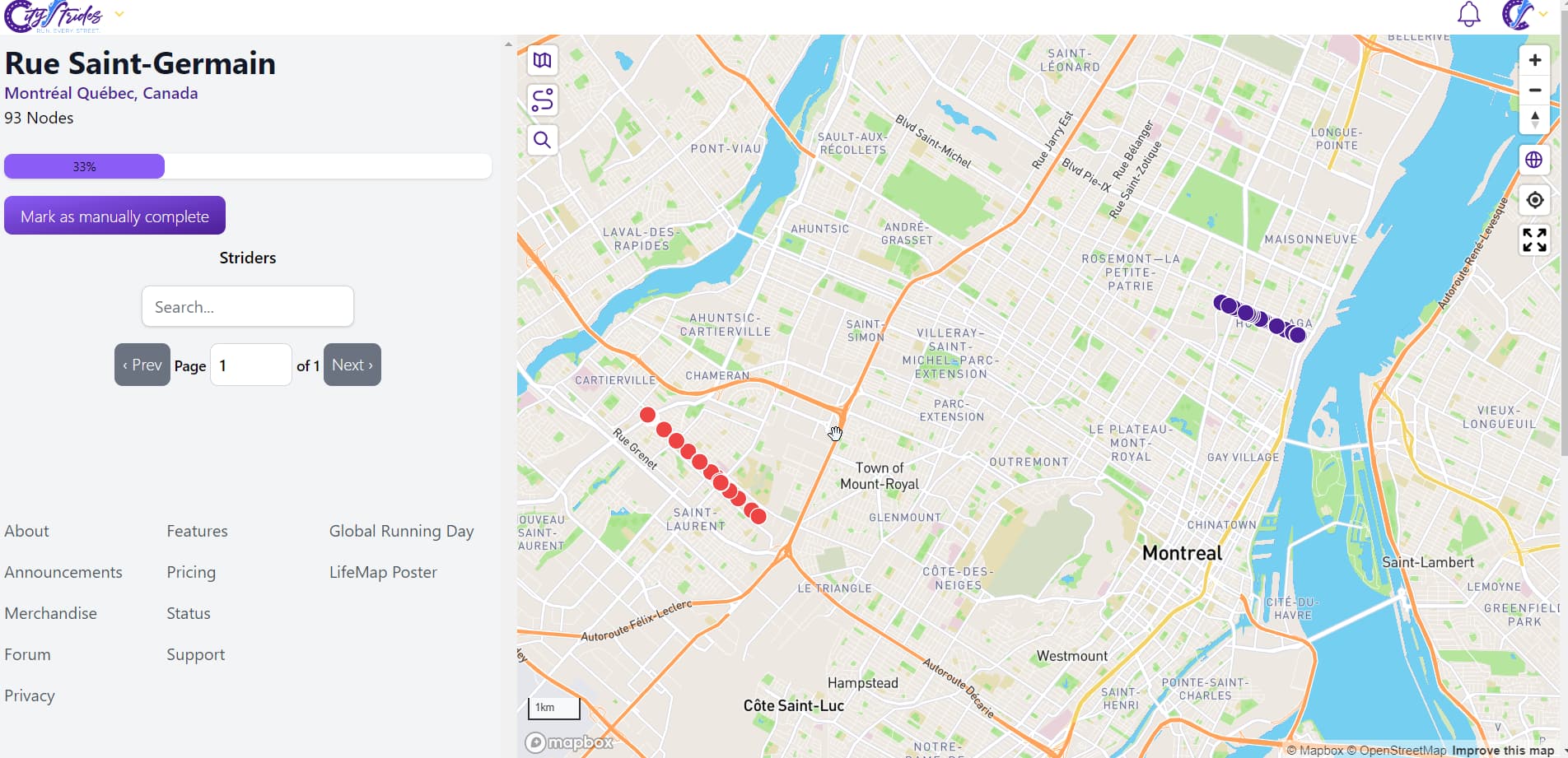
The reason seems to be that there are actually 2 streets in Montreal that have the same name.
See example for example this run: https://citystrides.com/activities/37463506
-
I fully ran ‘Rue Beauchemin’
-
But the streets appear in the ‘Progressed’ section (not as ‘Completed’).
-
The reason is that there is another street in Montreal with same name, so the system consider this as not complete.


I thought this would be an exception case but the same happened in the next run ( https://citystrides.com/activities/37525103 ) with ‘Rue Saint Germain’:
I then realized that this issue was quiet common in Montreal, especially with ‘numbered street’. See for example ‘10eme avenue’ is split into 4 different streets that are clearly not the same:
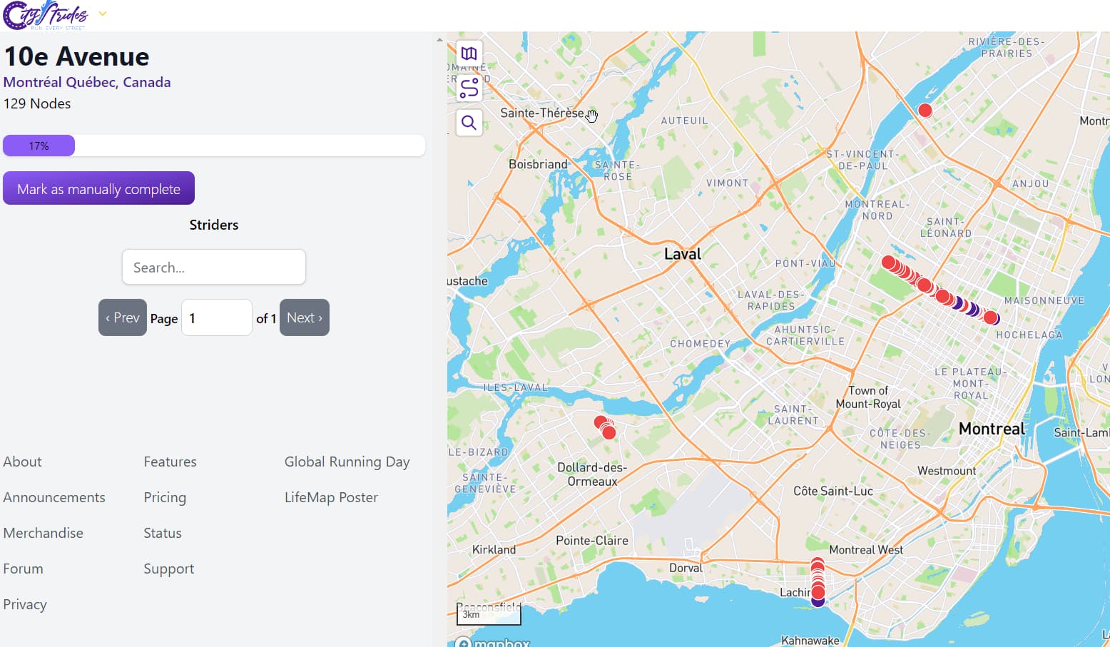
The city might require a more granular split.
Note sure if this can be solved, but wanted to let you know about it.
Thanks and keep up with the great work!
Mathieu
Hello! Came across a weird one today! I finished all the nodes on a street called Mansionhouse Road, but it came up on City Strides as only partially complete, because it was merged with another street of the same name several miles away! I wonder if there are other examples of this and how they might be separated?

This is a pretty common thing and if they’re in the same municipality the best solution is to run both! But if you don’t plan on getting over to the other Mansionhouse Road anytime soon, in the meantime you can mark it manually complete.
This is a well-known and often-discussed situation.
It stems from the fact that OSM (where CS gets its data) has no real understanding of a “street” so @JamesChevalier has to come up with a way to group things. He uses naming, so sometimes there is weirdness like this.
This is one of many different threads, but it has some good info in it.
Thanks for the replies - I did a search before posting but used the wrong terms I think as I didn’t find your other posts! It’s fine in the long run (no pun intended) as I will run both was just curious why it happened in the first place.

@tev4 I remember when I moved to Boston everyone telling me “be careful to get the zip code right when you’re trying to go to an address on Washington Street with rideshare” and that screen you shared doesn’t even include the Washington Streets in Brookline or Cambridge or any other municipality bordering Boston, which there surely are ![]()
It’s much of the same in a rural area or Portugal where the organization is at the county level for a bunch of tiny hamlets. “Rua Principal” basically means “Main Street” Rua Principal - CityStrides