I wondered if it has been considered to exclude OSM roads with highway=service?
I can see from overpass turbo that highway=services is an exclusion and so are some specific types of service roads.
but i would have thought most service roads should be exclude. It seems to be used for many things, from a road leading to a company building, to those inside a cemetery. these often fall in to a grey space of you might be allowed to be on them, but it is frowned upon.
The first requirement for a street to be on CityStrides is for the street to have a name. Very few service roads have names, so it’s probably not a huge problem.
Personally, if it has a name and it’s legal to run on, I’ll be running it anyway. Heck, I even run some streets / paths / ruts that are unnamed just because…
If it has a name, and is OK to run on, I often find it might be classified wrongly. I have changed several streets like that to e.g unclassified or residential in OSM
This image shows a couple of examples.
Top left is basically the service road/car park of a home for a building, it so happens to be for a charity for domestic abuse, I imagine they really don’t want random men running around their building.
I had already changed the status to driveway. but have not checked and indeed it had the name or the organisation. on OSM I have removed the name, added the building and added the name to the building.
You can also see one of the cemeteries I mentioned, the roads do have names here, however I’m not really sure its right to by running around a cemetery, even if allowed access.
The issue I have is that a lot of these service type roads have the name “Access Road”, so come over to CS as runable streets… When updating OSM, I have left that the same, but set the part of the road that is gated off as “private”, so only the section of the road that is truly accessible is left as is.
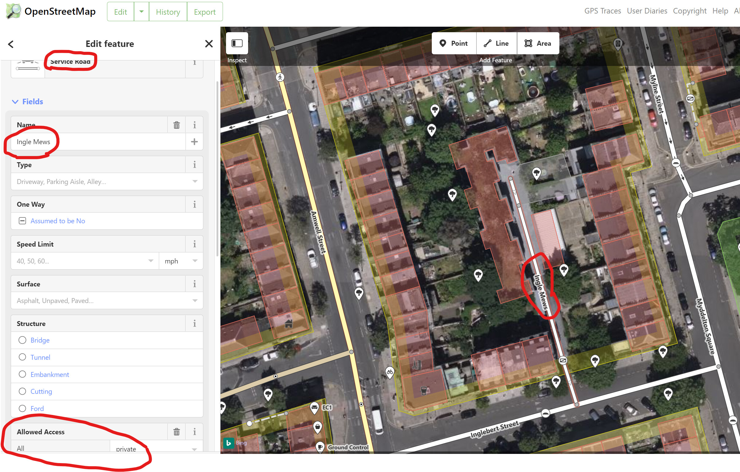
Service roads are pulled into the CityStrides map, whether they are named or not. Where they have been tagged as private would it be possible, @JamesChevalier , for those to be shaded grey, as per private residential roads?
It’s hard to distinguish between the thickness of a named residential street and a named service road on the CS map on a phone screen while running. Seeing a named white line makes me wonder why my pre-planned route isn’t collecting it, so I inevitably have to stop and double-check where I’m going. Seeing the named service road in grey would help considerably. Example below of Ingle Mews (in the London Borough of Islington, UK) which is private and gated in OSM but is hard to distinguish from any other named street in CS
Can you share a link to an example street in CityStrides? Un-named streets should not be present, so I’ll want to start there.
actually, after reviewing the screenshots, it sounds like you might be talking about the map and not the data in the CityStrides site. The map is generated by Mapbox, it’s not from CityStrides data. I have some control over styling, but I’m not sure if I have control at the OSM tag level.
Well, that certainly answers a question I had which is a variation on the theme. I couldn’t understand why the MAP contained so many driveways, shopping center parking lots, and in my particular geography, an actual service road to a municipal water treatment plant. I was wondering why CityStrides [map] was showing so many ways that are private property and therefore shouldn’t be runnable, but now I know what we see on the map is [usually] a superset of the ways we need to run for a particular city. I am, however, finding it a nuisance to have to zoom in on all these little ways to verify that they don’t have a name, and are therefore unlikely to be in the CityStrides DATABASE. Rhetorically, why does MapBox think peoples’ private driveways (and some of these other odd-ball features) are worthy of display to the general public?
It’s entirely possible that I have it all wrong - I’m not good with Overpass query language at all - but it does seem like polygon Way records get returned, so I also have to purposefully exclude them.
For example, this query - overpass turbo - retrieves both of the highway=services Way records in Ludlow, MA. I’m somewhat certain that if I didn’t exclude the services tag, these odd records would make their way into CityStrides.
Yes they would of course
Perhabs both should be excluded then. I see plenty of highway=service roads with names like ‘parking access’, ‘deliveries road’ etc.
I moved us over to another thread, since we’re talking specifically about service roads & this seemed relevant.
I can’t think of a reason to keep highway=service roads in CityStrides, but since I haven’t done it yet I think it’s worth playing around in Overpass Turbo to check those in various cities. I can’t recall if there were some cities with lots of mis-tagged service roads or something…
Indeed. Running this on relation 2989158 which is the same city as in my previous examples shows there’s plenty of actual streets tagged as highway=service when they should be either highway=residential or highway=unclassified. That’s a headache . In this situation I think it is better to keep the service roads in CS and try to add access=private or foot=no where it makes sense for those that shouldn’t be there
I definitely think highway=service should be included (when they have a name). There are so many examples of this in my neighboring cities where I have run and they all seem very much like any other ”CityStride eligible streets”
This caught my eye and I realized there’s some ambiguity in OSM for service roads. In my area, there’s loads of single lane ways to get to one or three houses, some private or not, some paved or not, some named or not. I most often see these labeled as “service”, since residential’s example looks nothing like these and “minor/unclassified” is described as an access road, non-residential.
From the wiki, Roads to individual dwellings would normally be tagged as [highway]=[service] (and likely [service]=[driveway]). If they have a name and are public, I’m counting it in my to-do list!