Help me test my Garmin "cul-de-sac" problem?

I noticed sometime around last Nov, 2024, that I was no longer getting navigation prompts on my Garmin Epix Pro (Gen 2) when a course I’d laid out involved walking into and back out of a cul-de-sac.

This worked flawlessly for the year starting in Nov '23 when I got the watch.

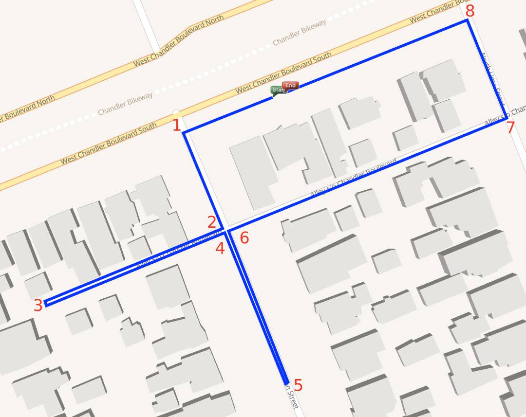
For example, each of these arrowed turns went by unprompted–by either the watch nor an auditory prompt on my phone:

The major street left-or-rights are still working properly–but there’s something about these short in-and-outs that is confusing the watch.

I’m working with Garmin support to try and figure out what changed 5 months ago, but they seem to be struggling…

Are there any citizen citystridin’ scientists out there (ideally with the same or very similar watch) that might be willing to test this function? I want to try and determine if perhaps “…it’s not you, Garmin, it’s me” or not.

Ideally you’d plan a course with two or three short cul-de-sacs here in CS, export it into Garmin Connect, then transfer it to your watch and run or walk the resulting course–noting if the nav prompts are working properly.

For example, I have a dead-end alley half a block from me that I often test with. It doesn’t have to be as elaborate as the course I posted above.

Thanks in advance, striders! :saluting_face:

[edit] Garmin keeps asking me to check my GPS settings–thinking, I guess, that accuracy is the problem–but this watch will show which side of the street I’m on. You can even spot where I ducked into a construction port-a-pottys along the way (!), so it doesn’t make sense that that would be the issue.

I’m also having 2 separate but related issues with audio prompts on my Garmin Enduro 3. I got my watch in October 2024 and had no issues with audio prompts on Courses run with the watch until sometime in February. Initially I contacted them because I was getting audio prompts with excessive information, always going 3 decimal points out on any value, i.e., “In 821.324 feet, turn left”. They have been unable to solve it for 2 months, and in the meantime, sometimes I don’t get audio prompts at all - just silence. It seems random, and I can’t get just normal useful audio prompts, I can only get too many decimal places or silence. The customer service person I’ve been corresponding with also told me to change my GPS settings to no avail. I check in with them weekly and they have nothing for me, I don’t get the impression that it’s a very high priority to figure out even though it’s almost certainly a software glitch on their end…

So, thanks for sharing this because I have a similar issue and experience. Hope they get their act together soon…

I can’t help with testing, but I wonder if the way the route is built could help…

When mapping a cut-de-sac, zoom way in and drop multiple markers down one side of the street, then square off your route at the end of the street, then drop a few markers coming back to the main road.
Big :person_shrugging: energy on this, but maybe if it’s forced to be a continuous path as opposed to an out-and-back where there’s only one coordinate dropped at the end of the cul-de-sac it’ll allow the navigation prompts.

Yeah, I’ve been getting the multi-decimal place prompts as well… :person_facepalming:

1 Like

I considered this–and may have tested it once–but I don’t remember the outcome. I just planned todays route, maybe I’ll go back and build in some ‘fake’ cul-de-sacs with method.

Well today’s test: I had one way point at the end of a dead-end alley, and it correctly prompted the turn-into, u-turn, and turn out of. A very short distance later it completely missed the cul-de-sac that I had entered several way points for.

There were multiple u-turns on ‘regular’ streets that were successful–but another failed prompt to turn part way down a street and turn around.

I should test if there is any difference depending on which Garmin app I use: My only choices are “Hike” and “Run” (there is no “Walk” app available.)

And I’m still getting the distance prompts down to 1/1000th of a foot. “In 64.536 feet, make a left turn”

[edit] Here are the navigation prompts successes and fails:

(The two red X’s had multiple waypoints–especially the top one.)

OK, so I’ve run some tests this morning, changing some variables, and logging the results. (There’s a lot of variables, so I haven’t tried every permutation.)

This is my Test Route, with 8 navigational prompt points.

1, left turn
2. right turn
3. u-turn
4. right turn
5. u-turn
6. right turn
7. left turn
8. left turn

I plotted the route in the Garmin Courses section and loaded it to my watch, and I plotted the route on the CS plotter and imported it into Garmin Connect and then to my watch.

I can provide more details if interested, but

The BEST (and only 100% “correct”) execution was plotting the route in Garmin as a RUN. (The same route plotted on Garmin and executed as a HIKE, missed 1,3,4,5 & 6.)

The best a CS plotting could do was with loading up on waypoints (more than I would typically use to plot a 4 or 5 mile citystride). That involved putting a waypoint at every turn and some “mid-cul-de-sac” ones. Not a practical solution. Even then It missed the first left turn (#1), and wanted me to make a “hard left” turn between turns #2 & #3 (turning me around before I reached the end of the alley (#3).

[Point 3 is an actual dead-end alley; point 5 is just part way down a thru street]

I’m beginning to wonder if my cul-de-sac failure beginning in Nov of '23 might have been a case of the neighborhood I was in just having more cul-de-sacs than previous neighborhoods–rather than, say, a software update by Garmin.

It also curious that the Garmin “Hike” app is so comparatively poor at hitting every navigational prompt. (It missed, 1,3,4,5 & 6.) Although very few actual, literal hikes (ie, in ‘nature’) would involve lots of “turn down this trail for 100’ then bang a U-ey”!

Not sure why the RUN app would be more diligent–unless it’s just a more sophisticated app in general.

And there is no WALK app (which is how I do my Citystrides).

In the absence of any changes to the way Garming and/or CS works, it looks like when I plot neighborhoods (typically in hilly residential areas), I’ll have to open both Garmin Connect to actually plot the route, wit the CS Lifemap open for reference.

Wonder if another plotting website would perform any better? (ie, MapMyRoute, etc?).

Leave it to a Citystrider to stress-test the system(s)! :winking_face_with_tongue:

It would be interesting to compare the underlying data of the Garmin Run route and the CityStrides route. The CityStrides route page has a vertical three dot menu that lets you download a GPX file. If the Garmin Run route can be exported in the same format, we could compare the two and see where the data differs. Maybe there’s something I can manipulate in the CityStrides route that would get it to work with the navigation features better.

I think that’s possible! Can I attach a .zip file here? If not, I’ll upload it somewhere…

[EDIT] OK, here’s a link to a spreadsheet that has links to the .gpx files (I hope). Let me know if there are some specific scenarios/routes/plotting you’d like me to repeat…

No surprise that Garmin would take this position (they might be right!):

Thank you for your thorough testing and information. I did get confirmation from the team that it is possible to see differences in the courses when importing third party data. For the most accurate course tracking, we do recommend creating on Garmin Connect.