Yes, definitely sounds like a level between region (state) and city would be useful for you. Has this been considered before @JamesChevalier ?
1 Like
A contrasting dilemma is that New York City has Boroughs and Community Boards in addition to county an state borders, so dense metro areas might be overwhelmed.

Was thinking about this today. I’m about to finish Mina de Água, Lisboa - CityStrides, which is not actually a city but a neighborhood of the City of Amadora. I would love when I’m done do display the boundaries for this one as well as the other 5 neighborhoods that compose Amadora…
With this idea I’d like to add a sub-idea: City names on CS maps are actually hyper-links to the city’s CS’s page.
One way to address the “what’s next to my city” issue is to use the node hunter: go to the place you want to identify, activate node hunter, click on the node to find out what city it’s in.
This won’t help with the visual border display, but it’s a start ![]()
1 Like
I think It would be a super handy feature to have a tab in city view where one could quickly see (and navigate to) adjacent or neighboring cities. I have no idea if this information is easy to retrieve from OSM. But anyway that’s what I was thinking.
Now I often find myself going back and forth between cities via my profile page.
Sometimes, especially when I have no running history in a city and when I don’t know the exact name, it’s pretty hard to navigate to the map for neighboring cities. This adjacent city tab would solve those problems.
Similar to this idea: All city boundaries displayed on Lifemap
1 Like
But now doesn’t Node Hunter only shows nodes for the city map you are on?
That’s the way it seems to be working for me, and I haven’t figured out a way around it.
OK, small work around…
From a city map, the state (small text above the city) is also a hyper-link. Node Hunter also works on the state map, you just have to pan and zoom way down to the area you are interested in…
Then clicking the red node works great for identifying the city!
Node hunter works on the lifemap as well, point it anywhere to get the city info from the nodes.
2 Likes
Thanks, I forgot about using LM. ![]()
I’ve been poking around at this a little bit. I have something “usable” in that it technically works but it’s very super not fun to use ![]() and is just a standalone test page for now and unfortunately seems to use quite a bit of bandwidth. It’s super early in the development cycle - I just got the basic interaction working “well enough” a few minutes ago - but it’s enough to start getting into it. I’ve found that including you all in my building process usually results in a better outcome.
and is just a standalone test page for now and unfortunately seems to use quite a bit of bandwidth. It’s super early in the development cycle - I just got the basic interaction working “well enough” a few minutes ago - but it’s enough to start getting into it. I’ve found that including you all in my building process usually results in a better outcome. ![]()
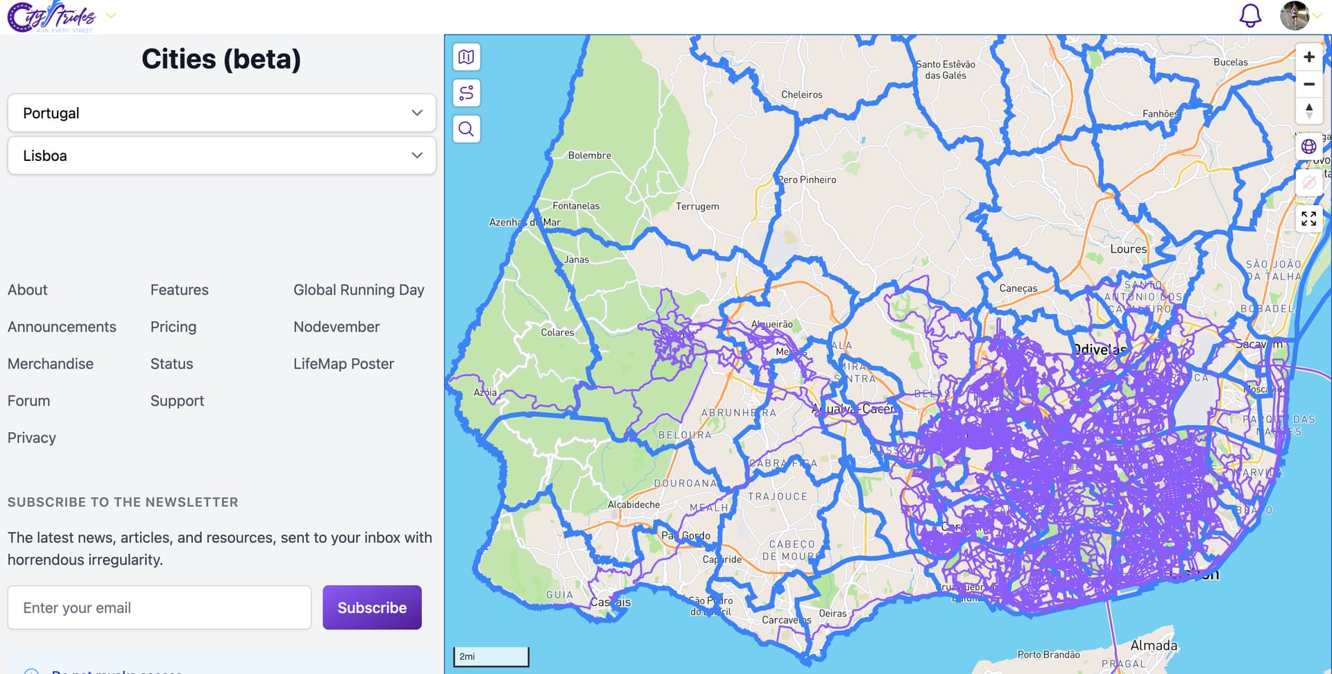
This is supporter-only because of the additional costs. You can visit City Boundaries (beta) to check it out.
I’d love to hear everyone’s thoughts/opinions/suggestions as to what this feature can become.
Read on for more notes…
The country/region menus don’t have any type-to-filter capabilities. Ultimately, I don’t want you to have to futz with menus and stuff, but I needed some interface to play around with the basic idea of what’s going on here. So, on desktop it does respond decently well to typing the first few letters of the country or region name. On mobile, it’s pretty trash involving lots of scrolling & the region list is real bad. Probably don’t try that region filtering on mobile.
If you hover over cities, they’ll become an opaque blue and display its name. If you click a city, it’ll take you to its page. You can use the browser’s back button to get back to the globe view.
I think you can still do other stuff like route planning on this page, but I’m not certain. I’d expect that you’d want to be able to carry on with all of your other typical site use, even with all the city borders displayed. So that’ll eventually need to be confirmed to be working…
I do think the workflow that was originally shared stands up… An additional “city borders” button (be it in the map or in the left column/bottom area in mobile) that toggles the visibility of them.
That opaque blue hover feature is great in this global view of checking out cities around the world (similarly the popup city name display), but I’d imagine it would be terribly disruptive within your day to day use. Maybe that feature would only be enabled on specific pages. ![]()
If you spot city import issues, like I did almost immediately ![]() … please do not report them here, instead create a new thread in #support:global-coverage-support
… please do not report them here, instead create a new thread in #support:global-coverage-support
8 Likes
I really like this already!
As you say yourself, the filtering needs work. In addition to the menus just being not good to use right now, I would like to have some option of showing “nearby” cities in some form. I live near the border of my region, so the “region” filter isn’t the best. One idea would be a “show city borders on current map” button that shows all city borders on your currently shown part of the map. Another one would be an option to show all cities bordering a specific city. I don’t know if either of them is technically feasible.
Most features seem to be usable (e.g. the route builder works fine), but the label with the city name gets in the way sometimes (it overlaps with the names of past runs, as one example). You also can’t click on past runs because clicking on the city has priority.
For me, the best solution would probably be a button to toggle city borders on/off.
Edit: Node Hunter doesn’t seem to work for me in that view, though.
2 Likes
Lovely first try.
some things i noticed.
No lifemap on the map. That would make it amazing
When switching to a city by clicking, and then back to the screen before, is not working. Several navigation issues i noticed.
I hope this could go to the release, it’s really a good add-on imho.
1 Like
One can toggle the Lifemap using the little tri-fold map icon in the upper left of the map.
1 Like
I can’t speak to the cost side of things, but on a desktop, this functionality is fantastic. It does so much of what I was hoping for. I’ll need to play with it a bit more, but I really like what I see.
I wonder if a “light” version might be available just as a reference for non-supporters? This could answer a lot of questions with a link to that map when someone says “how come my run didn’t complete any streets” and it is because the run wasn’t within any borders. It could be a static, regularly, but infrequently updated, non-clickable map…
1 Like
Looks really cool James. Incredible looking at all the difference countries and seeing how the data differs. Even between provinces, Alberta versus BC for instance. I’m not sure how it’s implemented, but for the UI on the lifemap, if you simply had it so that hovering over the border allowed for selection (same way as hovering over an activity allows for selection) then I think that would be perfect. And just having a button to show / hide city border (same as show/hide lifemap) would seem great. I’d have them on by default pretty much all the time, depending on how they were plotted.
I am seeing the same thing. Turning node hunter on-and-off doesn’t appear to do anything, and when you next click on a city to look at it, although it works, an error message pops up.
Agree here, probably your bandwidth and server usage would go way down if it defaulted to off and toggled on a small section, somehow. I’m more in favor of Dominik’s first suggestion, and you could have a cap similar to the Node Hunter error message that you can only display XXX maximum boundaries in a given view. Or even an error message saying to zoom in further for this functionality to work, etc. etc.
One “bug-or-feature?” item: Lisboa is a nested city, and when I hover over some neighborhoods it brings up the individual nested neighborhood, but doing the same for others brings up the whole city. I was trying to think through what the difference is between the neighborhoods. At first I thought that the ones that I’ve completed 100% are the ones that cause the full city mask to come up instead of the neighborhood, but then I realized that doesn’t quite hold. So I don’t know why some do and others don’t, or what you’d want nested neighborhoods in big cities to do in general
This looks really neat, but it would be interesting to brainstorm a better contrast between the blue/purple.
1 Like
I’m unclear about the bandwidth/cost issues here. Don’t you just cache all the lines? (Technical implementation question, here.) Or do city boundaries change that frequently?
Same thing for Stockholm, it’s got 13 nested cities, for eight of them I get the nested city, for the other five I get the parent, and there are both 0 and 100% among those five