Elevation - The grasshopper API mentions elevation so maybe possible? Beneficial for judging how hilly a planed route would be. If we were able to see elevation profile that showed where hills are,
Straight line distance - When switching to straight line mode (ex: when you know a shortcut, hop a fence, etc), the straight line distance is not counted. In most instances the straight line distance is short before jumping back to snap mode but perhaps there are some that build mainly in straight line mode
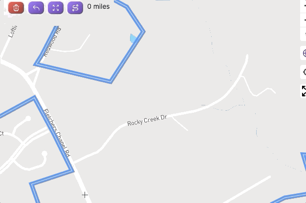
Example: See the distance increase when selecting the first non-start position. Then switch to straight line and after clicks distance stays the same.
I’ll poke around at adding another button to show/hide the elevation detail, with straight-line sections set to 0, and hopefully overlaying that along the bottom of the map (probably the piece I’m most concerned about; the map containers are pretty different between desktop & mobile).
It should have already been doing this - I missed a small piece of code, though. The next release will include this fix.
I was thinking that elevation detail would be useful for planning routes and then I found this post. James suggests that a button to show/hide elevation detail might have been added but I can’t find it, was it removed or just wasn’t created?
I’ve got a technically functional version of elevation display working locally, but I’m really struggling on the UI side of things. It gets super complicated when including both desktop and mobile in the decisions.
On desktop, there’s a ton of space to put it
Top right, which kind of pairs evenly with the existing Route Builder popup UI
Pinned to the bottom, which kind of gets in the way of the bottom left measurement UI and the bottom right attribution UI … but I can probably figure out a way to avoid colliding with those.
On mobile I don’t really see any usable space. The map view is already pretty small.
Maybe I can figure out a way to toggle the elevation display so on desktop it pushes the map up (appearing a lot like your first screen shot) … and on mobile, it leaves the map as-is and places the elevation UI below that (partially covering the text content below the map).
The way Garmin solves it on mobile is pretty nice: slide-up tab with elevation and other route detail. I think it’s ok to not have elevation and map on-screen simultaneously on mobile, maybe it could go in a tab next to the streets the route will complete?