# Is it possible to remove nodes on a 3,4km stretch of Hump Yard Road
**URL:** https://community.citystrides.com/t/is-it-possible-to-remove-nodes-on-a-3-4km-stretch-of-hump-yard-road/24553
**Category:** Support
**Created:** [March 13, 2022, 10:42pm UTC](https://community.citystrides.com/t/is-it-possible-to-remove-nodes-on-a-3-4km-stretch-of-hump-yard-road/24553 "2022-03-13T22:42:22Z")
**Posts on this page:** 14
**Page:** 1
### Author:  [@alvinrichardnb](https://community.citystrides.com/u/alvinrichardnb)
#### Post date: [March 13, 2022, 10:42pm UTC](https://community.citystrides.com/t/is-it-possible-to-remove-nodes-on-a-3-4km-stretch-of-hump-yard-road/24553/1 "2022-03-13T22:42:22Z")
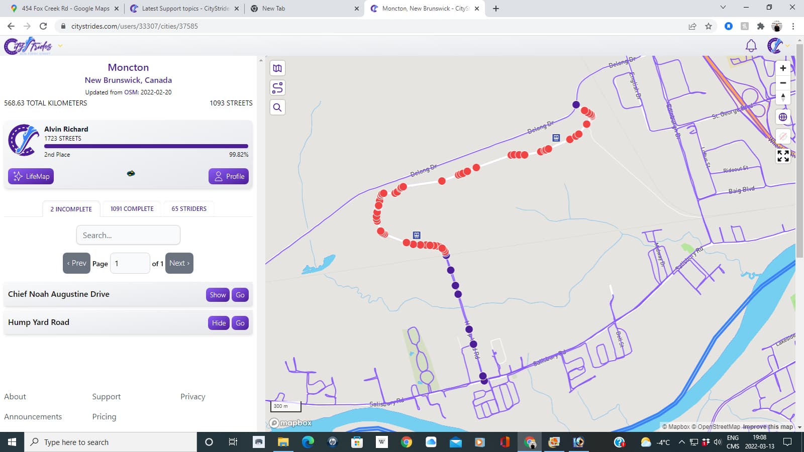
Also “Hump Yard Road” in Moncton, New Brunswick, Canada also has an issue. There is a 3,4 km section that I could not complete since it’s a private road owned by CNR (Canadian National Railway). The sign at the entrance says, “Private Roadway, Use by public is strictly prohibited unless authorized. Trespassers will be prosecuted”. On the City Stride map there is a train sign on both ends of the road which I could not complete. This road has a maze of train tracks where containers are loaded and unloaded. If you could remove the nodes on that section, it would be greatly appreciated.
---
### Author:  [@ericjrw](https://community.citystrides.com/u/ericjrw)
#### Post date: [March 14, 2022, 1:43am UTC](https://community.citystrides.com/t/is-it-possible-to-remove-nodes-on-a-3-4km-stretch-of-hump-yard-road/24553/2 "2022-03-14T01:43:33Z")
My gut feeling is that an OSM (Open Street Map) edit is required to mark that road as private. On the CS wiki page there is info on OSM and how to accomplish the edit.
---
### Author:  [@stst415](https://community.citystrides.com/u/stst415)
#### Post date: [March 14, 2022, 2:27am UTC](https://community.citystrides.com/t/is-it-possible-to-remove-nodes-on-a-3-4km-stretch-of-hump-yard-road/24553/3 "2022-03-14T02:27:43Z")
Hi, Eric. Yes, indeed, from what I’ve been learning, editing the road in OSM to “private” would fix the issue that Alvin brought up. But here’s an extension of that question that I’m wondering… _Where do the nodes themselves come from?_ Marking them private in OSM seems to mean that CS will filter them away. But OSM doesn’t have these nodes (or does it?), so they must come from a _different_ database or mapping system? If so, where is that?
---
### Author:  [@hjkiddk](https://community.citystrides.com/u/hjkiddk)
#### Post date: [March 14, 2022, 4:43am UTC](https://community.citystrides.com/t/is-it-possible-to-remove-nodes-on-a-3-4km-stretch-of-hump-yard-road/24553/4 "2022-03-14T04:43:14Z")
The road should just be marked private in OSM.
A guide for that is available in the wiki pages.
[https://community.citystrides.com/t/osm-basics/21283/27](https://community.citystrides.com/t/osm-basics/21283/27)
There is also a wiki page explaining the whole node thing and why you shouldn’t remove any nodes.
[https://community.citystrides.com/t/about-the-node-street-and-city-data/19802/2](https://community.citystrides.com/t/about-the-node-street-and-city-data/19802/2)
---
### Author:  [@hjkiddk](https://community.citystrides.com/u/hjkiddk)
#### Post date: [March 14, 2022, 5:05am UTC](https://community.citystrides.com/t/is-it-possible-to-remove-nodes-on-a-3-4km-stretch-of-hump-yard-road/24553/5 "2022-03-14T05:05:12Z")
I have changed it in OSM, should be gone from CityStrides in 2-3 weeks
---
### Author:  [@hans1](https://community.citystrides.com/u/hans1)
#### Post date: [March 14, 2022, 7:27am UTC](https://community.citystrides.com/t/is-it-possible-to-remove-nodes-on-a-3-4km-stretch-of-hump-yard-road/24553/6 "2022-03-14T07:27:16Z")
And to answer your other question, yes, the road is in OSM:
> **[Way: Hump Yard Road (71069803) | OpenStreetMap](https://www.openstreetmap.org/way/71069803#map=14/46.0722/-64.8603)**
>
> OpenStreetMap is a map of the world, created by people like you and free to use under an open license.
---
### Author:  [@stst415](https://community.citystrides.com/u/stst415)
#### Post date: [March 14, 2022, 8:08am UTC](https://community.citystrides.com/t/is-it-possible-to-remove-nodes-on-a-3-4km-stretch-of-hump-yard-road/24553/7 "2022-03-14T08:08:06Z")
Henrik, thanks for that great link! It didn’t answer my question above, though, so maybe I wasn’t clear. When I asked where the _nodes_ were from, I didn’t mean the OSM nodes-in-ways, but the _red nodes_ that we see on CS. See the screen cap. Those don’t line up with the nodes-in-ways, so I feel as if they’re from another source (but maybe not?).

---
### Author:  [@hjkiddk](https://community.citystrides.com/u/hjkiddk)
#### Post date: [March 14, 2022, 9:02am UTC](https://community.citystrides.com/t/is-it-possible-to-remove-nodes-on-a-3-4km-stretch-of-hump-yard-road/24553/8 "2022-03-14T09:02:10Z")
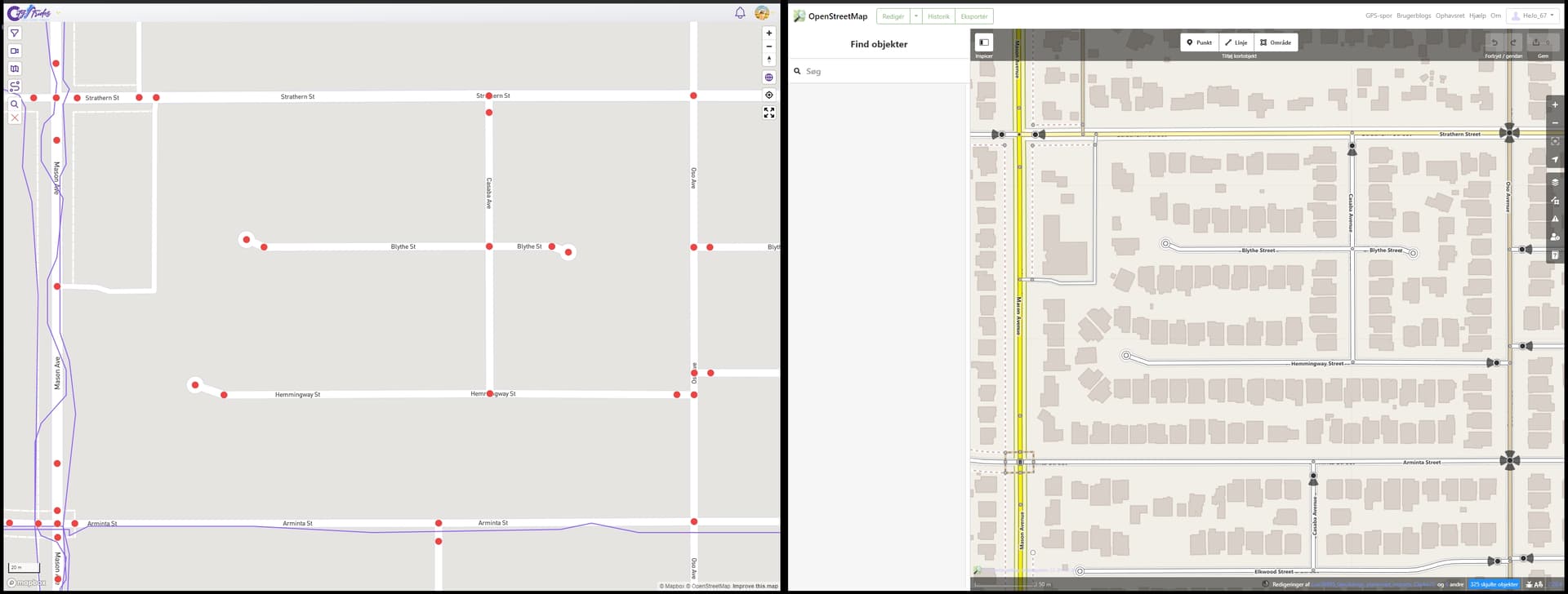
The nodes in CS are from the OSM data. Line up perfectly.
I can’t explain it better than James wiki page about the Node, Street, and City Data.
[https://www.openstreetmap.org/edit#map=18/34.21413/-118.57754](https://www.openstreetmap.org/edit#map=18/34.21413/-118.57754)
[https://citystrides.com/users/27988/map#34.214175594845145,-118.57737418755744&17.627019883304005](https://citystrides.com/users/27988/map#34.214175594845145,-118.57737418755744&17.627019883304005)
---
### Author:  [@hjkiddk](https://community.citystrides.com/u/hjkiddk)
#### Post date: [March 14, 2022, 9:03am UTC](https://community.citystrides.com/t/is-it-possible-to-remove-nodes-on-a-3-4km-stretch-of-hump-yard-road/24553/9 "2022-03-14T09:03:34Z")
---
### Author:  [@hans1](https://community.citystrides.com/u/hans1)
#### Post date: [March 14, 2022, 11:42am UTC](https://community.citystrides.com/t/is-it-possible-to-remove-nodes-on-a-3-4km-stretch-of-hump-yard-road/24553/10 "2022-03-14T11:42:22Z")
You might not have noticed that to see all nodes in a road you must select/highlight the road in OSM. In Henrik’s picture from OSM, you have to click on Hemmingway Street to see the nodes, now you see that there are two nodes at the western end

---
### Author:  [@alvinrichardnb](https://community.citystrides.com/u/alvinrichardnb)
#### Post date: [March 14, 2022, 2:28pm UTC](https://community.citystrides.com/t/is-it-possible-to-remove-nodes-on-a-3-4km-stretch-of-hump-yard-road/24553/11 "2022-03-14T14:28:30Z")
Thank you so much in my behalf and from those who will attempt to run all of the streets in my city!

---
### Author:  [@ericjrw](https://community.citystrides.com/u/ericjrw)
#### Post date: [March 14, 2022, 3:40pm UTC](https://community.citystrides.com/t/is-it-possible-to-remove-nodes-on-a-3-4km-stretch-of-hump-yard-road/24553/12 "2022-03-14T15:40:59Z")
@stst415 In case it was not clear, there can be “points” aka nodes anywhere. Sometimes they are used to show a road as curved. They are also present when ways (roads) intersect. And sometimes nodes are on ways for no apparent reason.
There is a topic in the forum about completeness, or hard mode, where all the nodes must be collected. In that thread is an example of a strider who was collecting all the nodes, but not running the length of the street.
Some interesting replies ensued, and one was to add more nodes to ways to make doing the above more difficult. As I recall, this would have been considered “vandalism”, if I’m remembering the word used. Regardless, it is frowned upon.
But this doesn’t mean that some ways have superfluous nodes.
Hope this helps, Eric
Ps. Perhaps the subject was all streets or all nodes?
---
### Author:  [@stst415](https://community.citystrides.com/u/stst415)
#### Post date: [March 20, 2022, 6:28pm UTC](https://community.citystrides.com/t/is-it-possible-to-remove-nodes-on-a-3-4km-stretch-of-hump-yard-road/24553/13 "2022-03-20T18:28:21Z")
Hans and Eric, I’m sorry I didn’t reply earlier in the week. Yes, I’m familiar with the nodes and ways within OSM (I’ve been crash course learning, and making hundreds of additions now over these last many weeks), but I guess I had an idea that red CS nodes were different (perhaps because not all always showed up, or perhaps because of people collecting only nodes instead of lengths of streets). Regardless, I did a few tests and see that, indeed, they are one and the same. All good.
Side note. Knowing that now, it boggles my mind even more why someone would choose to _only_ collect nodes… All it would take is for some OSM user to decide a street isn’t PERFECTLY straight to add a few nodes that would suddenly mean that the CS user would need to go back to hit it again. Or what if somebody else adds driveways that creates more nodes on that street? Running the entire length guarantees you’ll _keep_ that particular street no matter what future updates are made. {shrug}
Anyway, thanks! 🙂
---
### Author:  [@ericjrw](https://community.citystrides.com/u/ericjrw)
#### Post date: [March 22, 2022, 1:47am UTC](https://community.citystrides.com/t/is-it-possible-to-remove-nodes-on-a-3-4km-stretch-of-hump-yard-road/24553/14 "2022-03-22T01:47:36Z")
> [@stst415](#):
>
> some OSM user to decide a street isn’t PERFECTLY straight to add a few nodes
As I recall, this is frowned upon by the OSM community. There is a post, somewhere here in the CS forum, that said this would be called (I think) vandalism (if I’m remembering the correct word) within the OSM community.
I’ll see if I can find that post.
Found it: [All Streets or All Nodes? - #41 by petje](https://community.citystrides.com/t/all-streets-or-all-nodes/22964/41)